Skip to content

Autonomous Municipality of Guaynabo

en_US EN
en_US EN es_PR ES
  • Home
Menu
  • Citizens
    • Service Request
    • Family Services
    • Services to the Elderly and Persons with Disabilities
    • Housing
    • Security
    • Arts and Culture
    • Head Start
    • Sports Program
    • Medical Services
    • Emergency Management
    • Transportation
    • Environmental Control & Recycling
    • Planning & Land Management
    • E-Pay
Menu
  • Business
    • Establish your business here
    • Permits
    • E-Pay
    • Supplier Portal
    • Business Forms
  • Jobs
  • Notices
Menu
  • Government
    • Mayor's Office
    • Municipal Legislature
      • Municipal Ordinances
      • Municipal Legislature
    • Municipal Dependencies
    • Municipal Secretariat
    • Transparency
    • Federal Programs
    • Planning and Land Management
Menu
  • Get to know us
    • History
    • La Marquesa
    • Gastronomy
    • City Maps
  • Events
entypo_text-document Report it
Menu
  • Home
  • Citizens
    • Service Request
    • Family Services
    • Services to the Elderly and Persons with Disabilities
    • Housing
    • Security
    • Arts and Culture
    • Head Start
    • Sports Program
    • Medical Services
    • Emergency Management
    • Transportation
    • Environmental Control & Recycling
    • Planning & Land Management
    • E-Pay
  • Business
    • Establish your business here
    • Permits
    • E-Pay
    • Supplier Portal
    • Business Forms
  • Government
    • Mayor's Office
    • Municipal Legislature
      • Municipal Ordinances
      • Municipal Legislators
    • Municipal Dependencies
    • Municipal Secretariat
    • Transparency
    • Federal Programs
    • Planning and Land Management
  • Jobs
  • Notices
  • Get to know us
    • History
    • La Marquesa
    • Gastronomy
    • City Maps
  • Events
Menu
  • Residents
  • Business
  • Government
  • History
  • Services
  • Tourism
  • Virtual Complaint

Geographic Information System (GIS)

file
Return to
  • A Geographic Information System (GIS) is a set of methods, tools and data that are designed in a coordinated way to store and analyze geographic and visual information to satisfy multiple purposes and decision-making needs.
  • This system combined with Satellite Images and Digital Aerial Photography offers a terrestrial inventory service of the entire territory that makes up the Autonomous Municipality of Guaynabo. In this way, digitized and updated maps are obtained to provide a better service for the various projects, developments and plans of the Municipality.
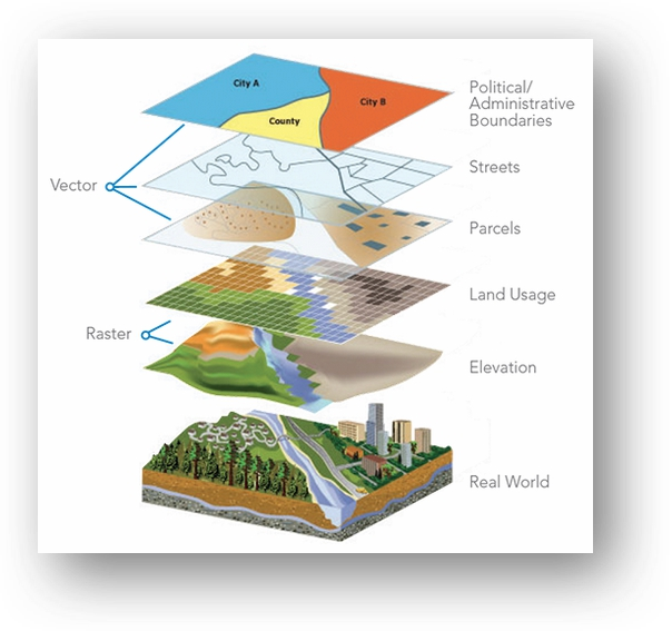
  • Geographic information layers (Layers) are represented by points, polygons or lines. By combining them we can visualize the real world and where they are located in relation to each other.
Thank you for visiting us!
Do not forget to register as a user to enjoy all the services that our portal has.
Follow us at
Facebook Instagram Youtube Social network X

Don't forget to register to be informed of all our events.

When registering on the Guaynabo Municipality website and providing your email address, you are accepting that this information will be exclusively used for official communication purposes by the Municipality. We are commited to protecting your privacy and will not allocate your information with third parties without your prior consent, unless required by law.

  • Should be Empty:
Thank you for visiting us!
Contact us at
Autonomous Municipality of Guaynabo
P.O. Box 7885
Guaynabo, PR 00970
Telephone (787) 720-4040
Navigation
  • Home
  • Establish your business here
  • Mayor's Office
  • History
  • Request for services
  • Municipal Legislature

Copyright 2024 Autonomous Municipality of Guaynabo | All rights reserved.

Scroll to Top